
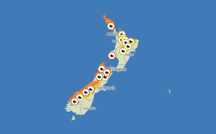
A powerful storm sweeping across New Zealand over the King's Birthday long weekend has triggered heavy rain warnings, watches, and emergency preparations from Fiordland to Northland. Tasman District Council has warned locals that the event could be the most significant weather the region has faced since flooding tore through in June and July 2025, causing an estimated $50 million in damage.
Orange heavy rain warnings cover Westland, Fiordland, the headwaters of the Canterbury lakes and rivers, Tasman District, Nelson City including the Richmond and Bryant Ranges and the Rai Valley, the Buller Ranges, Taranaki Maunga, and Northland. Yellow heavy rain or strong wind watches are active for the headwaters of Otago lakes and rivers, Auckland and Great Barrier Island, the Taranaki Region, Bay of Plenty, Rotorua, Taupō, Tongariro National Park, the Marlborough Ranges, and the Coromandel Peninsula. A strong wind watch previously issued for the Canterbury high country has since been cancelled.
MetService says heavy rain is expected to begin across northern and western parts of the South Island on Sunday, moving into Taranaki from midnight into Monday, then reaching Northland from noon on Monday and Bay of Plenty from 6pm that same day. For some areas, conditions are forecast to persist through to Tuesday.
Tasman District Council has been direct about what lies ahead. The council describes the storm as "at least a moderate event" for the district, with some areas set to experience "the largest" weather event since the 2025 floods. Residents have been asked to stay off the roads. The heavy rain warning for Tasman runs until 4am Tuesday, with Golden Bay, the Tākaka Hill, the Riuwaka River, the Upper and Lower Motueka, and the Richmond Ranges behind Nelson and Richmond all expected to be significantly affected.
"With a long-duration rainfall event and potential heavy falls towards the end of the period, both slips and treefall risk are high towards the end of the warning period. Surface flooding is likely in all areas, including elevated flows in small streams," Tasman District Council said. The council also flagged that Monday night's high tide is likely to coincide with the strongest NNE winds, with gusts potentially reaching 60km/h in exposed locations, and that coastal erosion and rapidly rising streams and rivers during thunderstorms were additional concerns.
🟧🟨❗️Severe Weather Warnings and Watches have been updated for Significant Heavy Rain over large parts of Aotearoa and northerly gales over the Canterbury High Country. 🌧️🍃 All the details herehttps://t.co/os2FgIcKqk@NZcivildefence @nztamain pic.twitter.com/ZnMmVzDpYO — MetService NZ (@MetService) May 30, 2026
In Marlborough, the district council has highlighted a further complication: if the weather system stalls over the southern Richmond Ranges on Tuesday morning, rainfall could become prolonged and impacts magnified. The region's emergency management team has been activated. Based on the MetService forecast issued Sunday evening, high water levels are expected in the Pelorus River, with flooding likely at Dalton's Bridge on State Highway Six. Motorists are being asked to avoid overnight travel on State Highway Six through the Havelock, Pelorus, and Canvastown area over the next few days, as the road could flood or close at short notice.
Flooding and slips are a genuine prospect across the affected regions. By mid-afternoon Sunday, surface flooding was already appearing on State Highway 6, the main route linking West Coast towns, with the New Zealand Transport Agency reporting hazardous driving conditions. The agency warned anyone travelling in the west and top of the South Island to prepare for potential highway closures. Drivers travelling between Hokitika and Haast were urged to take particular care, with up to 450mm of rain forecast for Westland until 8pm Monday.
West Coast Emergency Management noted the rain arrived slightly later than forecast on Sunday and confirmed it would continue monitoring the situation. Since 4am Sunday, 81.8 millimetres of rain had been recorded at Milford Sound, with a similar amount falling south of Hokitika.
In the North Island, MetService forecasters say Taranaki Maunga could receive up to 300 millimetres of rain before 9am Monday, while localised parts of Northland could see up to 200 millimetres before 8am Tuesday.
Roads identified as being at particular risk include SH60 between Richmond and Collingwood, SH6 from Hira to Havelock, SH6 from Nelson to Murchison, SH65 between O'Sullivans Bridge and Lewis Springs, SH63 through the Wairau Valley, and SH1 between Blenheim and Seddon. Drivers have been urged to keep across road and weather conditions, as closures may occur at short notice and affect long weekend travel plans.
"Ignoring a closure not only puts your safety and those of your passengers at risk but also endangers emergency service staff who may have to rescue you," an NZTA spokesperson said.
Westland Mayor Helen Lash said she was hopeful the weekend's heavy rain would prove manageable for the region, as it was expected to arrive over a prolonged period.