
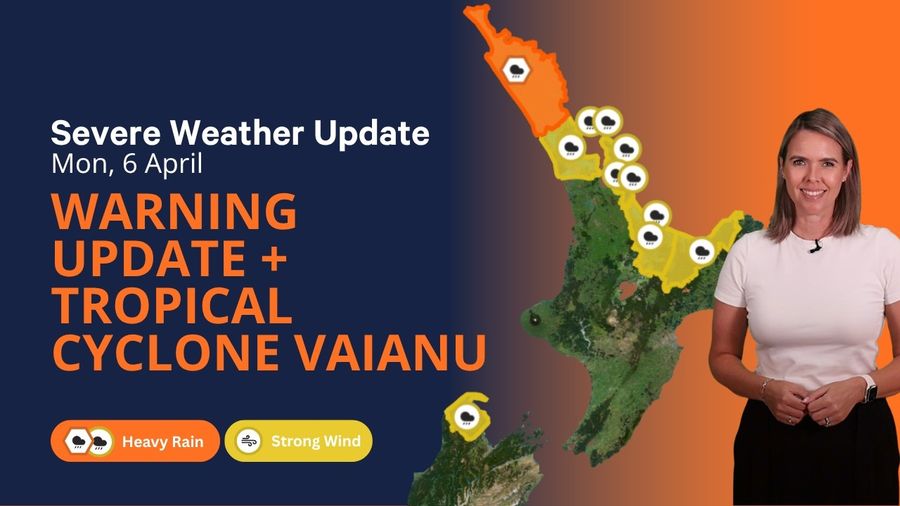
Two active tropical cyclones are tracking through the South Pacific, and MetService has warned that one of them may bear down on New Zealand within the coming week.
Cyclone Maila is currently situated in the Solomon Sea, while Cyclone Vaianu lies east of Vanuatu. Vaianu has forecasters most focused. MetService forecaster Louis Fernando described it as a Category 2 system that is strengthening and accelerating.
"It is looking like it will intensify to a Category 3 either later today or into tomorrow," Fernando said.
Vaianu is presently moving through the corridor between Vanuatu and Fiji, though its trajectory beyond that point carries real uncertainty. "Some of the models are indicating that perhaps towards the weekend the remnants at least of the cyclone could affect parts of the North Island," Fernando said.
Long before any cyclone influence could reach the country, significant rainfall is already bearing down on the upper North Island. MetService issued an orange heavy rain warning for Northland covering the period from 10pm Monday through to 4pm Tuesday, together with a strong wind watch commencing at 3am Tuesday. Heavy rain watches were also in place for Auckland, the Coromandel, and Bay of Plenty.
Northland, particularly its northern and eastern areas, is expected to receive between 90 and 120 mm of rain. The region was already dealing with the aftermath of serious flooding at the end of March, with some communities still working through recovery.
MetService meteorologist Alec Holden acknowledged that while forecasters were confident something significant was on the way, pinpointing which areas would be worst affected remained difficult. "The models have been quite jumpy. We've been getting a lot of different solutions of where the worst of the rainfall is going to be from run to run," he said.
🟡🔶🌧️💨 New Severe Weather Watches and Warnings have been issued. To read the full Watches and Warnings go to the MetService websitehttps://t.co/HZ2TSD5rV7@AucklandCDEM @CivilDefenceWKT @BOPCivilDefence pic.twitter.com/IJThhXL8fn — MetService NZ (@MetService) April 5, 2026
Holden characterised the broader weather picture as New Zealand being "sandwiched between two competing systems." To the northwest, a large area of low pressure was pushing across and southward through the country, but a ridge of high pressure was slowing its progress considerably.
"To the northwest of the country, we have this very broad area of low pressure that is attempting to move over the country and down south," he said. "However, blocking its path, or rather slowing it down significantly, we have a ridge of high pressure."
That standoff between the two systems was channelling more showers and persistent wet weather onto the eastern seaboard. The low had been drawing a substantial feed of moisture from the subtropics, and that flow was set to push across the country over the coming days. "Later today, and then through tomorrow and Wednesday, this broad low pressure system that's been drawing this big feed of moisture from the subtropics is going to be trucking its way over the country," Holden said.
Those combined conditions were the driving force behind the warnings and watches issued across the upper North Island. Holden advised people in areas under watches and warnings to keep up to date with the latest forecasts and follow any guidance from Civil Defence.