Picture a device that needs no batteries, folds flat until the moment it is needed, and can be picked up not only by conventional radar but by the kind used aboard satellites, meaning a vessel carrying one could be spotted anywhere a satellite passes overhead.
That device now exists. A few months ago, researchers alongside the New Zealand Defence Force completed a successful final sea trial of the latest prototype, a unit called SAR4SaR, and the results moved people to tears.
"There were tears all around," says Dr David Galligan, director of Defence Science and Technology at the NZDF. "I got a picture through of the snap that they got back from the radar satellite and you could very clearly see the bright spots on the water."
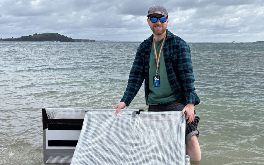
What Galligan was looking at is an unlikely-looking piece of technology. Corflute, gaffer tape, and plastic sheeting have been fashioned into two triangular wedges fastened back-to-back, with aluminium foil lining the corners. It looks like something assembled in a home garage or at a Scout camp. But this is the SAR4SaR prototype, the product of nearly two years of field trials and a substantial body of design work before that.
SAR4SaR was developed as a joint project between DST and the University of Auckland's Space Institute. Dr Tom Dowling works there alongside his research assistant Ella Fasciana, and Dowling can be found standing in the gentle wash at Mission Bay beach in Auckland, trouser legs rolled to his knees, holding the odd-looking object steady on the surface.
The name SAR4SaR stands for Synthetic Aperture Radar for Search and Rescue. It exploits an imaging technology already in use aboard satellites, and understanding how it works begins with a fundamental limitation of traditional radar: the bigger the antenna, the sharper the picture, yet a satellite or aircraft cannot carry the kind of large rotating antenna a ship might use.
"Back in the 50s and 60s, they came up with this very cunning idea where you use the motion of the aircraft to create the length of your antenna," Dowling explains. "So the synthetic aperture part of synthetic aperture radar is the way in which we create a giant kilometre-long antenna due to the motion of the spacecraft or the aircraft to let us do this really high-resolution radar work."
For SAR4SaR to function, the device had to be detectable by that synthetic aperture radar even in stormy ocean conditions. The solution lay in some elegant physics.
"The key thing here is that we're exploiting some really neat fundamental physics, which is these corner reflectors," Dowling says. Each of the foil-lined corners on the device features surfaces set at 90-degree angles to one another. When an electromagnetic pulse from a satellite strikes those surfaces, the energy does not scatter. "If you've designed that surface correctly ... what you get is this huge magnification, essentially, of the energy return. All the radar that's hitting it all gets collected and all of it gets bounced right back to the satellite."
On a radar image, that return combines with the movement of the surrounding ocean to show up as an intensely bright starburst. "It's the radar equivalent of lighting a flare and waving it above your head," Dowling says. "It just makes you super visible."
The origins of the design were considerably more modest. In the Space Institute lab, Fasciana brings out a plastic lunchbox filled with small objects folded from bright origami paper: her earliest experiments to find a shape that could lie flat but spring open to produce the precise corner angles required to reflect the radar signal.
"Starting with paper was really easy to just work with and really quick to assemble," she says. Promising shapes could be drawn up in CAD software and run through a computer model that would show whether or not a given form would produce the desired starburst effect.
Beyond radar reflectivity, the design had to satisfy several other requirements at once. It needed to fold down flat and compact enough to stow on even a small vessel, deploy quickly in an emergency, and be inexpensive to produce while remaining waterproof and tough enough to handle rough conditions at sea.
The most promising candidates were built into prototypes from the same kinds of cheap materials, then put through many rounds of testing. Earlier this year, the Navy took one prototype south to test near sub-Antarctic Campbell Island, in some of the world's most demanding conditions. There were two goals, Dowling explains: confirming that the reflectors still worked at high latitudes, where the satellite angles shift, and proving the device could survive a battering.
"The gusts were up to 50 knots, which was spicy, it's fair to say, and these things were spinning around like crazy, which then led us to realise we need to add some more design elements to help keep them more stable on the sea surface."
Further refinement followed. Across June and July 2025, the team worked intensively at Omaha beach, eventually arriving at what Dowling calls the "offset caterpillar" configuration, two wedges joined back-to-back with a half-width offset between them.
"It was just three weeks non-stop with no break whatsoever: back out on the water, cool, that mechanical fix worked great, build another set of test versions and then out on the water for the big final trial."
That final trial brought together commercial satellites, an Air Force Poseidon aircraft, and the University of Auckland research vessel.
"That's a lot of people doing a lot for us," Dowling says. "I'm very pleased to say that after a very stressful month or two, we did have something that worked spectacularly well."
There are still significant steps between a working prototype and a product that could be carried aboard boats across New Zealand and the Pacific. Manufacturing at scale from more durable materials, while holding down costs, presents one challenge. Another is the question of satellite data access, much of which is controlled by commercial operators.
"There is what I would describe as a patchwork system at the moment," Dowling says. "So we're still working on that and exactly how that would look like."
Because satellite passes introduce some delay between a vessel's last detected position and when that data reaches rescuers, search teams will still need drift modelling to account for how far a person or vessel may have moved. Even so, the precision on offer is far beyond what is currently available in many situations.
"The quicker they get it to us, the more precise that position to search is... What we'll be able to do is say, this was their position an hour or two ago." The uncertainty, Dowling adds, will still be tightly constrained. "It will end up in the region of a kilometre or less, I would say."
Interest in SAR4SaR has come from both local and international quarters. At a conference in Hawaii, Fasciana spoke with an attendee from Tonga who voiced frustration that most existing technical solutions to the same problem depend on costly, non-repairable equipment, or on devices such as EPIRBs that require imported batteries.
The appeal of the SAR4SaR approach, Fasciana says, is its simplicity: "you get one and you have it till you use it and [it's] super low-tech, so there's nothing to maintain and it just sits there".
At the Coastguard New Zealand conference this year, the response was equally encouraging. "Everybody in that room went, 'Oh, yes, please. We can see the immediate use-case,'" Dowling recalls. "If people out there had this, we would be able to find them much faster, much more easily."
The hope driving the whole project is a straightforward one: that one day, even the smallest boat on New Zealand's waters might carry a SAR4SaR device, and that carrying it might save a life.